Crustal Architecture and Images

|
IGCP Project 559
Crustal Architecture and Images |
 |
|
contact us: contact@earthscrust.org.au | about us
|
|
34th International
|
Updated: Jun 02, 2016 IGCP Project 559 - Seismic ImagesA Brief Description of Crustal Images from the Donbas Foldbelt, SE UkraineCompiled by Randell Stephenson (email:randell.stephenson@falw.vu.nl); and Sergiy Stovba (email:stovba@naukanaftogaz.kiev.ua ) TECTONIC SETTING – Intracratonic inverted rift basinThe Donbas Foldbelt (DF) is the uplifted and deformed part of the up to 20-km thick Dniepr-Donets Basin (DDB) that formed as the result of rifting in the East European Craton (EEC) in the Late Palaeozoic. It separates the Azov Massif of the Ukrainian Shield from the Voronezh Massif. Dniepr-Donets Basin rifting, accompanied by voluminous magmatism, may have been driven by plume activity (Kusznir et al., 1996; Wilson and Lyashkevich, 1996) given the contemporaneous development of other rift basins on the East European Craton (cf. Nikishin et al., 1996; Stephenson et al., 2006). Intraplate compressional deformation of the basin (inversion) occurred mainly in the Late Cretaceous-Early Tertiary (Saintot et al., 2003; Stovba and Stephenson, 1999), presumably related to Alpine orogenic events in the Tethyan Belt on the southern margin of the East European Craton (cf. Stephenson et al., 2001). 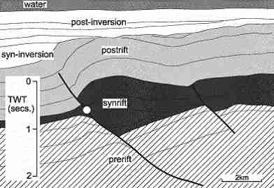
Fig. 1 – Schematic of sedimentary basin inversion (from Turner and Williams, 2004), Gelogical Era / PeriodThe Donbas Foldbelt (DF) part of the Dniepr-Donets Basin (DDB) is located in the south-eastern part of Sarmatia, the southernmost of three East European Craton segments (Bogdanova et al., 1996; Shchipansky and Bogdanova, 1996). Sarmatia includes the Archaean-Palaeoproterozoic Ukrainian Shield (UkS) and the Voronezh Massif (VM), which are separated from each other by the Late Palaeozoic Dniepr-Donets Basin. The Precambrian basement is exposed in the Ukrainian Shield and is covered by thin Mesozoic-Cenozoic sediments in the Voronezh Massif. The Ukrainian Shield and Voronezh Massif together form a large basement uplift with a diameter of some 1000 km. The main rifting event initiating the Dniepr-Donets Basin occurred in the Late Devonian with post-rift extensional rejuvenations during the Carboniferous, including the latest Carboniferous-Early Permian (Stovba and Stephenson, 1999; 2003). Minor basin inversion affected the Donbas Foldbelt in the Late Triassic; this intensifies to the south-east, along strike of the Dniepr-Donets Basin, and diminishes to negligible to the north-west in the Dniepr-Donets Basin. The main tectonic shortening event (inversion) occurred in the Late Cretaceous-Early Tertiary (Saintot et al., 2003; Stovba and Stephenson, 1999) and this also diminishes to negligible in the Dniepr-Donets Basin north-west of the Donbas Foldbelt. Global and Societal SignificanceThe DOBRE profile, that crosses the Donbas Foldbelt (DF) segment of the Dniepr-Donets Basin (DDB), represents one of only a few deep seismic profiles (of high quality) that entirely images an inverted intracratonic rift basin and subjacent crust and upper mantle. It reveals that the Mesozoic-Cainozoic shortening of the Dniepr-Donets Basin occurred at a crustal scale as a mega-pop-up structure, involving a major detachment fault cutting the entire crust and an associated back thrust mostly within the sedimentary succession (Maystrenko et al., 2003). One consequence of inversion and uplift in the Donbas Foldbelt is the emplacement of the thick Carboniferous succession of the Dniepr-Donets Basin and its rich coal resources at and near the exposed surface. Historically the Donbas Foldbelt is one of the most important coal mining regions of the former Soviet Union, now straddling the border between Ukraine and Russia and led to the development of heavy industry in this area. Other Tectonic Analogues
Location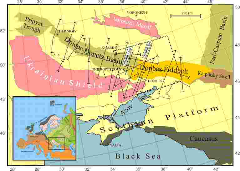 Fig. 2 – Regional tectonic setting of the Dniepr-Donets Basin The Dniepr-Donets Basin (DDB) is a Late Devonian rift basin located on the south-western part of the East-European Craton (EEC), striking in a south-easterly direction to the contiguous Donbas Foldbelt (DF) in eastern Ukraine and southern Russia where it joins the Karpinsky Swell (the southern margin of the Peri-Caspian Basin). The width of the rift (Fig. 2) varies between 60-70 km in the north-west and 140-160km in the south-east. Sediment thicknesses (comprising Late Devonian syn-rift and Carboniferous-Palaeogene post-rift successions) increase from about 2km in the north-west to about 20km in the Donets segment of the basin (e.g. Stephenson et al., 2001). Seaismic Images of the Earth's CrustPrior to DOBRE, there were some thirteen Deep Seismic Sounding (DSS) profiles across the Dniepr-Donets Basin and Donbas Foldbelt (DF), spaced at intervals of 50-150 km, one longitudinal profile, and several on the flanks of the rift (Fig. 2). Most of these studies took place in the 1960s and involved high-density (100m station spacing) recording of seismic arrivals with maximum offsets of 60-160km and were primarily designed to determine intrabasinal and intracrustal structure. The depth to the base of the crust was interpreted mainly from secondary (reflected) phases in the offset range 35-40km and greater. In general, these studies provided a good indication of the disposition of the basement surface (top of the "consolidated crust") and a first-order indication of intrabasinal geometry. The Moho was thought to deepen beneath the Donbas Foldbelt (cf. Stephenson et al., 1993; 2001) and, in the area adjacent to the Donbas Foldbelt, a crust/mantle transition zone (7.6kms-1) overlying upper mantle (8.0kms-1) was inferred. However, velocities from these earlier studies at depths greater than the upper crust, including those of the high velocity "crust-mantle" lens, were poorly constrained (being not controlled by refracted seismic phases; Ilchenko, 1996). 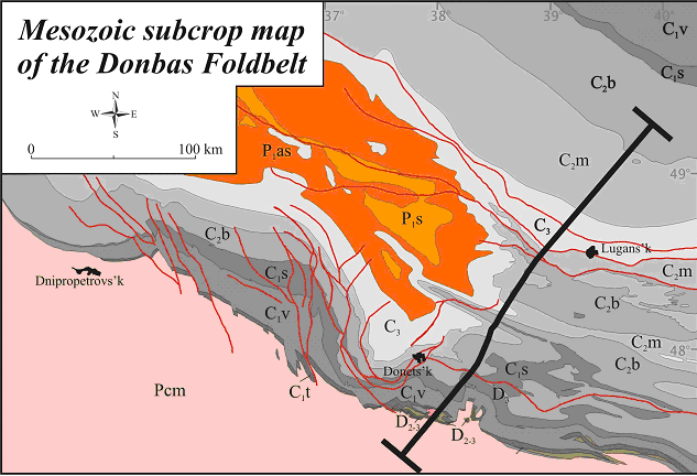 Fig. 3 – Mesozoic subcrop map of the Donbas Foldbelt area Seismic velocity structureA regional refraction/wide-angle seismic survey in the Donbas Foldbelt was carried out in August-September 1999 (DOBREfraction'99) as an integral part of a multidisciplinary study of the Dniepr-Donets Basin and Donbas Foldbelt initiated by the European Science Foundation EUROPROBE Programme. The survey comprised a main profile of length ~360km crossing the western Donbas Foldbelt and a subsidiary, parallel, off-line profile about 100km to the west in the Donbas Foldbelt (Fig. 2). The P-wave seismic velocity structure through the Donbas Foldbelt (DOBREfraction'99 Working Group, 2003) is shown in Figure 4. The velocity signature of the sedimentary basin itself is well resolved, indicating an asymmetric form, with a steeper basement surface in the south than in the north, and a total thickness of about 20km. There is a considerable degree of resolution of velocity layers within the sedimentary basin; most sediments, being Devonian and Carboniferous syn- and post-rift deposits that have been deeply buried, display relatively high velocities (~5.0-5.9kms-1). A thick (<10km) high velocity (<6.9 kms-1) lower crustal body lies beneath the rift basin itself, offset slightly to the north compared to the main basin depocentre, likely related to the rifting process; it has the form of a "rift pillow" forming as a result of lower crust being intruded by about 10% mantle material during rifting. Velocities in the crust below the Ukrainian Shield (UkS), south of the Donbas Foldbelt, are in general higher than beneath the Voronezh Massif (VM) to the north. The Moho displays only slight topography around a depth of 40km along the profile. Total crustal thinning across the Donbas Foldbelt (basement to Moho surfaces) is about one–half (stretching factor ˜2), roughly consistent with subsidence modelling inferences (cf. van Wees et al., 1996), but this could be greater depending on the degree of fractionation of mantle material now residing in a lower crustal high velocity layer – or "rift pillow" – lying beneath the sedimentary basin. 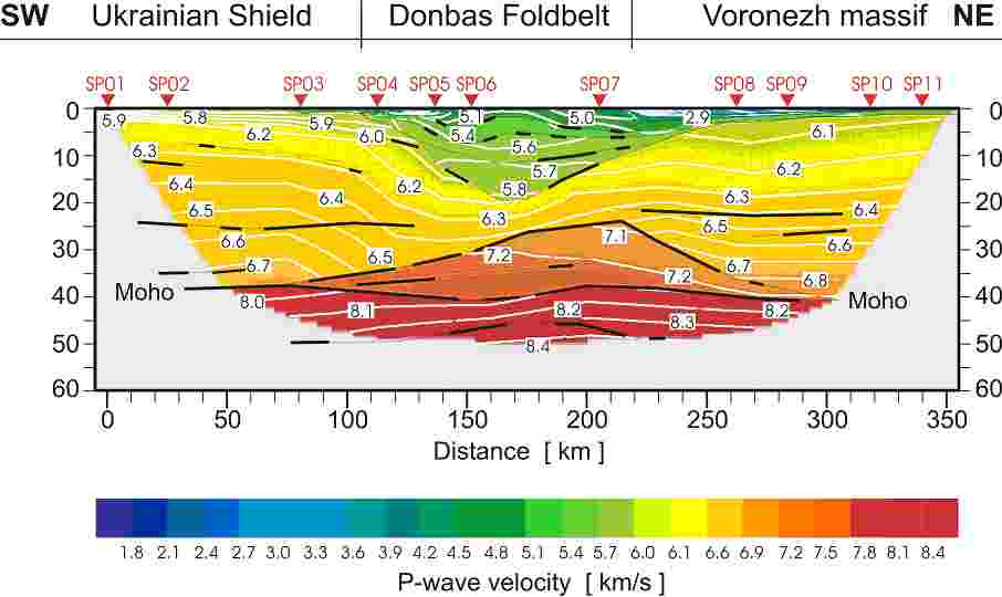 Fig. 4 – Seismic P-wave velocity model through the Donbas Foldbelt (DOBREfraction'99 Working Group, 2003). Horizontal axis shows model position; vertical scale is depth below the surface. The velocity field is contoured with a contour interval of 0.1kms-1. The coloured area is the area traversed by refracted rays, accordingly, the area where velocities are constrained. Layer boundaries and "floating" boundaries are indicated by lines. Thick lines mark positions where rays are reflected, indicating well-constrained boundary positions. [View larger image] Donbas Foldbelt crustal imageFig. 5 (below) shows the complete DOBREflection deep seismic profile across the central Donbas Foldbelt and its interpretation. Good to excellent resolution of the basin fill and the crystalline crust is evident. The south-eastern segment (0–140km) was acquired in 2000 by Ukrgeofizika with partial financial support through a consortium of institutions in Netherlands, Germany, and Denmark (DOBREflection–2000 and DOBREfraction'99 Working Groups, 2002) and the remainder in 2001 by Ukrgeofizika in the context of a Ukrainian national programme on sedimentary basins. Acquisition was with an "IO–2000" recording system using 681 channels and a geophone group spacing of 35m. A symmetric 24km split-spread (12–12km) was used in the southern part of the line, and an asymmetric 20 km spread (8–12km) was used on the northern part of the 2000 segment. The 2001 segment was acquired using an 18km symmetric spread and, otherwise, similar acquisition parameters. Processing of the DOBREflection data (by the Ukrgeofizika Technology Centre, Kyiv) followed a standard industrial processing sequence that included prestack procedures (statics correction, gain and mute analysis, predictive deconvolution, velocity analysis, residual static corrections, frequency analysis). Deconvolution, band-pass, and coherency filtering were then applied to the stacked data, followed by Kirchhoff time migration and a 45-degree time finite-difference migration. 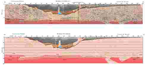 Fig. 5 – The DOBREflection full profile, compiled from the DOBREflection-2000 data set (left part; Maystrenko et al., 2003) and the DOBREflection-2001 data set (right part; Stovba et al., 2004); interpreted time seismic section (upper panel) and depth converted interpreted line diagram (lower panel). The Late Palaeozoic syn–rift and younger sedimentary succession is clearly distinguishable in the seismic section. The basement surface is imaged by a band of strong reflections, indicative of Devonian pre–rift sedimentary rocks (D2–3) unconformably overlying the Precambrian substratum and offset by faults formed during rifting and subsequent basin inversion (e.g. Maystrenko et al., 2003). The geological identification of this reflective packet is well established elsewhere in the Dniepr–Donets Basin (cf. Stovba et al., 1996; Stovba and Stephenson, 1999). The basement reaches the surface towards the southern end of the profile at the boundary of the Ukrainian Shield in accordance with the exposed geology. Towards the north–east, on the southern slope of the Voronezh Massif, the sedimentary succession thins markedly but Precambrian rocks are not exposed. The seismic interpretation in this area is confirmed by boreholes. Maximum depth to basement is about 23 km (8.2 s) in the axial part of the Donbas Foldbelt where the Devonian syn-rift complex (D3) has a thickness of about 8 km. This is overlain by a thick (~14 km) Carboniferous succession, comprising a broad post-rift syncline, that is exposed at the surface in the Donbas Foldbelt. A series of small syn-rift half-grabens can be seen on the southern flank of the Donbas Foldbelt as well as within the Ukrainian Shield. These grabens, and the southward thinning of Carboniferous strata, indicate that the original sediment fill likely continued considerably farther to the south. The Carboniferous overlaps Precambrian basement on the northern margin of the rift basin and, in this area only, is overlain by Triassic, Cretaceous, and Cainozoic units with a maximum thickness of less than 1 km thinning to the north-east. The Mesozoic–Cainozoic sediment thickness maximum occurs just to the north–east of an imbricate thrust zone formed during Mesozoic – mainly, possibly exclusively, Late Cretaceous – compressional events (Stovba and Stephenson, 1999; Stephenson et al., 2001; Saintot et al., 2003). It is the surface expression of a thrust zone cutting the entire crust, including duplications of the basement horizon and Moho, with a total horizontal shortening of 9 km (Maystrenko et al., 2003). In general, the entire crystalline crust is reflective, except for the uppermost part of the Voronezh Massif crust, which can be considered as a transparent zone. The Moho appears as a 1-2 s wide zone of strong reflectivity that is disrupted beneath the southern slope of the Voronezh Massif. Beneath the transparent upper crust of the Voronezh Massif, at depths greater than 15-20 km, the crystalline crust is strongly laminated and there are also dipping reflectors in the uppermost mantle, based on the depth of refraction Moho. The 1-2 s wide reflective band that expresses the Moho elsewhere along the profile is disrupted to non-existent in the area of the uppermost mantle reflectors. Based on the orientation of reflective events and the local absence of reflectivity, the middle and lower crust can be subdivided into several zones with different seismic fabric (separated by the red dotted lines in Fig. 5). There is excellent agreement between the regional basin architecture imaged on DOBREflection with the velocity model determined from wide-angle/refraction seismic (Fig. 6). Several velocity layers were resolved within the Donbas Foldbelt, comprising an asymmetric basin of 110 km width and up to 23 km depth (The DOBREfraction Working Group, 2003), exactly as determined from the reflection profile. P-wave velocities vary from 2.0-2.4kms-1 at the surface to 5.4-5.9kms-1 at the depth greater 10 km. The velocity model does not resolve any anomalous structure in the lower crust beneath the Voronezh Massif nor does it resolve the Moho duplication caused by the crustal-scale thrust zone. Otherwise, the refraction Moho corresponds with the base of the 1-2s reflective zone and is approximately flat at about 40 km along the entire profile. ). Crustal velocities are slightly lower in the crust of the Voronezh Massif compared to the Azov Massif, Vp/Vs ratios also smaller (1.73 versus 1.75), and uppermost mantle velocity is higher. Beneath the axial part of the Donbas Foldbelt, the lower crust and the Moho are characterised by exceptionally strong reflectivity that corresponds to a lower crustal high-velocity layer, with Vp<6.8kms-1. The high reflectivity in both normal incidence and wide-angle makes it likely that the zone originates from magmatic processes, such as intrusion of mantle melts into the lower crust during Late Palaeozoic rifting (The DOBREfraction'99 Working Group, 2003).  Fig. 6 – The DOBREfraction velocity model converted to two-way travel time superimposed on the time–migrated DOBREflection section (line diagram). Model velocities are: platform sediments of the Voronezh Massif – < 4.7km/s, lowermost sediments of the Donbas Foldbelt- <5.7-5.8kms-1 (orange); other sedimentary layers with intermediate velocities (blue-yellow); upper crustal layer - 5.9-6.8kms-1 (pink); lower crustal layer - 7.1-7.3kms-1 (light green); upper mantle - 7.9-8.3kms-1 (green), >8.3kms-1 (dark green). Crustal evolutionThe imbricate thrust fault zone on the northern flank of the Donbas Foldbelt connects with the thrust fault interpreted from the DOBREflection data cutting through the basement surface at km 110–120. In turn, this fault zone, if extrapolated to the southwest, links directly with the thrust fault interpreted to displace the Moho at km 30–40. Extrapolation of the complementary northeast–dipping reverse fault imaged on the southern flank of the Donbas Foldbelt (surface trace at km 55) leads to the intersection of both fault zones in the crystalline crust beneath the Donbas Foldbelt at a depth of 25–30 km at km 95. Together, these faults form a crustal-scale pop-up structure; the main detachment surface, dipping to the south–west and offsetting the Moho, controlled deformation during compressional inversion of the Donbas Foldbelt. The offset of this fault is greater at the Moho level than where it cuts the basement surface because of the shortening accommodated by the primary back–thrust and related reverse faults. A preshortening palinspastic reconstruction of the DOBREflection-2000 segment shown in Fig. 7 was derived by removing all reverse faults and folds that formed during periods of tectonic compression and then isostatically backstripping sedimentary layers to the base of the Carboniferous (~end of rifting). There are three main events depicted: crustal extension accompanied by magmatic intrusion in the lower crust during rifting (Late Devonian) followed by post-rift subsidence during the Carboniferous; monoclinal uplift and subsequent erosion of the southern margin of the Donbas Foldbelt in the latest Carboniferous-Early Permian; and shortening (basin inversion), mainly at the end of the Cretaceous (cf. Stovba and Stephenson, 1999). 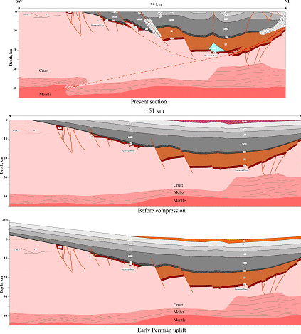 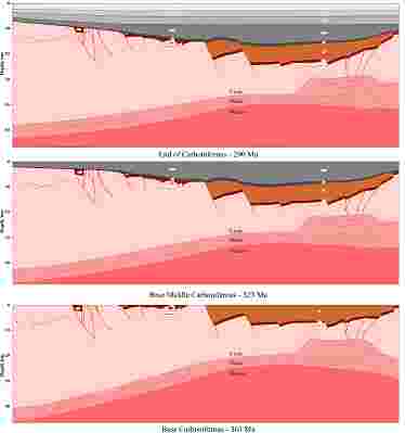 Fig. 7 – Suggested Late Palaeozoic-Cainozoic tectonic evolution of the Donbas Foldbelt along the DOBREflection-2000 seismic lines (expanded from Maystrenko et al., 2003). BbbliographyBogdanova, S.V., Pashkevich, I.K., Gorbatschev, R., Orlyuk, M.I., 1996. Riphean rifting and major Paleoproterozoic crustal boundaries in the basement of the East European Craton: geology and geophysics. Tectonophysics, 268, 1-21. DOBREflection-2000 and DOBREfraction'99 Working Groups, 2002. DOBRE studies evolution of inverted intracratonic rift in Ukraine. Eos, 83, 323, 326-327. DOBREfraction '99 Working Group (Grad, M., Gryn, D., Guterch, A., Janik, T., Keller, R., Lang, R., Lyngsie, S.B., Omelchenko, V., Starostenko, V.I., Stephenson, R.A., Stovba, S.M, Thybo, H., Tolkunov, A.), 2003. "DOBREfraction'99" – velocity model of the crust and upper mantle beneath the Donbas Foldbelt (east Ukraine). Tectonophysics, 2003, 371, 81-110. Ilchenko, T., 1996. The Dniepr-Donets Rift: deep structure and evolution from DSS profiling, Tectonophysics, 268, 83-98. Kusznir, N.J., Stovba, S.M, Stephenson, R.A., Poplavskii, K.N., 1996. The formation of the northwestern Dnieper-Donets Basin: 2-D forward and reverse syn-rift and post-rift modelling. Tectonophysics, 268, 237-256. Maystrenko, Yu., Stovba, S., Stephenson, R., Bayer, U, Menyoli, E., Gajewski, D., Huebscher, C., Rabbel, W., Saintot, A., Starostenko, V, Thybo, H., Tolkunov, A., 2003. Crustal-scale pop-up structure in cratonic lithosphere: DOBRE deep seismic reflection study of the Donbas Foldbelt, Ukraine. Geology, 31, 733-736. Nikishin, A.M, Ziegler, P.A., Stephenson, R.A., Cloetingh, S.A.P.L., Furne, A.V., Fokin, P.A., Ershov, A.V., Bolotov, S.N., Korotaev, M.V., Alekseev, A.S., Gorbachev, V.I., Shipilov, E.V., Lankreijer, A., Bembinova, E.Yu., Shalimov, I.V., 1996. Late Precambrian to Triassic history of the East-European craton: dynamics of sedimentary basin evolution, Tectonophysics, 268, 23-63. Saintot, A., Stephenson, R., Brem, A., Stovba, S., Privalov, V., 2003. Palaeostress field reconstruction and revised tectonic history of the Donbas fold-and-thrust belt (Ukraine and Russia). Tectonics 22, 1059 10.1029/2002TC001366. Shchipansky, A., Bogdanova S., 1996. The Sarmatian crustal segment: Precambrian correlation between the Voronezh Massif and the Ukrainian Shield across the Dniepr-Donets Aulacogen. Tectonophysics, 268, 109-126. Stephenson, R.A. and the EUROPR0BE Intraplate Tectonics and Basin Dynamics Working Group, 1993. Continental rift development in Precambrian and Phanerozoic Europe: EUROPROBE and the Dnieper-Donets rift and Polish Trough basins. Sedimentary Geology, 86, 159-175. Stephenson, R.A., Stovba, S.M., Starostenko, V.I., 2001. Pripyat-Dniepr-Donets Basin: implications for rift geodynamics and northern Peri-Tethyan tectonic history. Ziegler P.A., Cavazza W., Robertson A.H.F. (Eds.), Peri-Tethyan Rift/Wrench Basins and Passive Margins, Peri-Tethys Memoir 6, Mémoires du Muséum National d'Histoire Naturelle, 186, 369-406. Stephenson, R.A., Stovba, S.M., Tolkunov, A.P., Starostenko, V.I., Egorova, T.P., 2004. DOBRE-2000/2001 deep seismic reflection profile across the Donbas Foldbelt, Ukraine (abstract). Seismix Meeting, Mont Tremblant. Stephenson, R., Yegorova, T., Brunet, M-F., Starostenko, V., Stovba, S., 2006. Late Palaeozoic (rift) basins of the East European Craton, in: R.A. Stephenson and D.G. Gee (Eds.), European Lithosphere Dynamics, Geological Society of London Memoir, in press. Stovba, S.M, Stephenson, R.A., 1999. The Donbas Foldbelt: its relationships with the uninverted Donets segment of the Dniepr-Donets Basin, Ukraine, Tectonophysics, 313, 59-83. Stovba, S.M., Stephenson, R.A., 2003. Style and timing of salt tectonics in the Dniepr-Donets Basin (Ukraine): implications for triggering and driving mechanisms of salt movement in sedimentary basins. Marine and Petroleum Geology, 19, 1160-1189. Stovba, S.M, Stephenson, R.A., Kivshik, M., 1996. Structural features and evolution of the Dniepr-Donets Basin, Ukraine, from regional seismic reflection profiles, Tectonophysics, 268, 127-147. Stovba, S.M., Tolkunov, A.P., Stephenson, R.A., 2005. Regional investigations of geological structure and evolution of the Donbas Foldbelt (DOBRE international project). Problems of petroleum and natural gas industry, Kyiv: 21-34. Turner, J.P., Williams, G.A., 2004. Sedimentary basin inversion and intra-plate shortening. Earth-Science Reviews, 65, 277–304. van Wees, J.D., Stephenson, R.A., Stovba, S.M., Shimanovsky, V., 1996. Tectonic variation in the Dniepr-Donets Basin from automated modelling of backstripped subsidence curves. Tectonophysics, 268, 257-280. Wilson, M., Lyashkevich, Z.M., 1996. Magmatism and the geodynamics of rifting of the Pripyat-Dniepr-Donets rift, East European Platform, Tectonophysics, 268, 65-81. ContactsRandell Stephenson telephone: +31-20-598-7347 Sergiy Stovba telephone: +380-44-585-0207 |
| Disclaimer | Copyright | |